


Forest Service Suspends Prescribed Burns – Too Late For The Sangres
The Forest Service started prescribed burns on the east side of the Sangre de Cristo Mountains in, I don’t know, April. March? Earlier they had burned slash piles further north. I’m sure that some people closer to the locations of the April burns said really? With all this wind? Just as we did in 2000 when the Forest Service decided to do a prescribed burn on Cerro Grande, the spot where they thought a fire that could wipe out Los Alamos could start.
All those burns got out of control. Hundreds of houses were burned in Los Alamos in 2000. Dozens of small villages have been burned in the past couple of months on the east side of the Sangres. Thousands of prople had to evacuate. Watersheds have been damaged.
I wake up to smoke most mornings, thirty miles away. I am sick of it and sick for the damage to people and land. The house is full of smoke today. I have an air purifier given to me by a kind friend for my birthday that runs continuously.
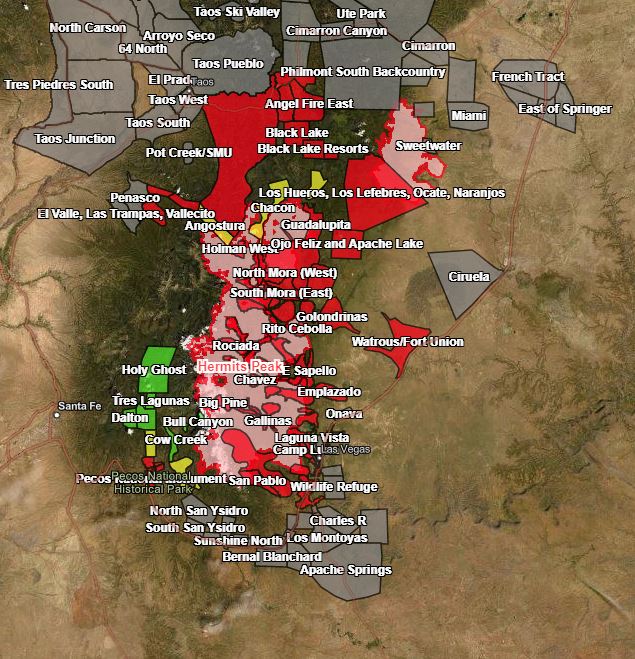
They are getting the fires under control. Slowly. There has been almost no rain since the fires started. For a while it looked like the fire might make it across the mountains to Pecos and then to Santa Fe. Pecos is still in danger. On the map, red indicates areas that should be ready to evacuate. Most of them evacuated earlier and have allowed people back. Green is still evacuated.
The Forest Service suspended prescribed burns last week, when they determined that a smoldering slash pile from January started the northern section of the fires. I’m not aware of an apology. New Mexico’s governor, Michelle Luhan Grisham, is insisting that the federal government pay for damages.
I’m not one of the people who want all prescribed burning ended, but as my head starts to ache from this morning’s smoke, it’s tempting. I know that the forests are full of fuel because of Forest Service policies starting early in the last century. I know that fire is the only way to deal with that fuel in some places. At this point, of course, it’s moot for the eastern side of the southern Sangres.
But Jeez Louise. I know that the Forest Service’s argument about Cerro Grande, from which I had to evacuate, was that it’s an odd place in the Jemez, only dry enough for fire yet wet enough for safety, for a short time in the year.
It’s possible that climate change has changed the rules of thumb that the Forest Service uses to judge when a prescribed burn is safe. I hope they look at that during this hiatus.
I had hoped to work on my flowerbeds this morning, but the smoke is worse outside. We are hoping for clouds and maybe rain in the next few days.
Map by Earthstar Geographics, made available on @GovMLG twitter account
Cross-posted to Nuclear Diner